


وصف لـ SkyDemon
SkyDemon is one of Europe's most popular solutions for VFR flight planning and in-flight navigation.
Use this app to access your SkyDemon subscription on your Android device, unlocking SkyDemon's powerful features while on the move.
FLIGHT PLANNING FEATURES
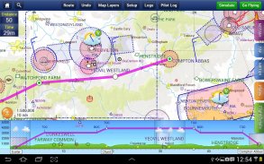
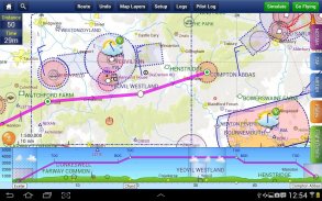
- SkyDemon vector charts are the clearest aeronautical charts you'll ever use, with dynamic airspace clipping and choice of map layers
- Route planning is as simple as touching consecutive waypoints and dragging to make changes
- Virtual Radar shows how your route relates to airspace, terrain, obstructions and other features
- Pilot Log facility calculates headings and groundspeeds from actual wind data, and shows useful frequencies
- Plates and other documents for relevant airfields are displayed automatically as you plan, and many are available georeferenced for use in flight
- Intuitive pan, pinch and rotate support with no loss of map clarity or text legibility
- File a VFR flightplan for your route directly to air traffic controllers
- Automatic TAF, METAR and SIGMET briefing as you plan a route, with graphical decoding
- Rainfall data can be overlaid on the main map, with animation, showing the trend of rainfall over time
- Integration of GAFOR route forecasts for Switzerland, Austria, Slovenia and Croatia
- Both narrow-route and area NOTAM briefings available, updated as you plan
- Advanced NOTAM graphical interpretation and depiction on the main map
- Easily print your PLOG and the output from various briefings
- Warnings for airspace and other potential hazards to your flight, updated in real time
- Airfield Admin Information shows useful contacts and other details for airfields featured in our charts
- Forecast winds aloft are automatically retrieved for the flight time and displayed on the map
- Create an advanced flight performance profile for each aircraft you use
- ATS Routes mode offers an alternative chart presentation for flight along airways
- Accurate fuel, weight and balance calculations including flight costings
- Create an unlimited number of user-defined waypoints
- Analyse your track logs for posterity
- Choose between six different vector chart styles
- Extensive European chart coverage as standard
GPS NAVIGATION FEATURES
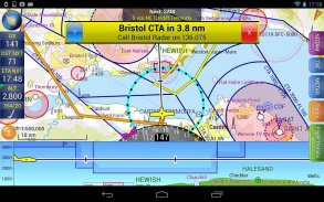
- Intelligent warnings for approaching airspace, NOTAM, obstacles, terrain and other hazards
- Virtual Radar shows a side-on projection of all approaching features and how your trajectory relates to them
- Vector map automatically follows the aircraft in north up, track up or course up orientation
- Clear and concise instruments show you flight statistics and help keep you on track
- An HSI/ILS instrument helps you keep to your planned route and line up early for approach
- Live Pilot Log shows progress through your route, ETAs, ATAs and useful frequencies based on your current position
- TerrainSafe dynamically colours mountainous terrain around you to quickly identify safer areas
- Direct To allows easy re-routing in a hurry by picking from a selection of nearby airfields
- Approach Information shows runway diagrams, TAF, METAR, NOTAM and other airfield details useful for making an approach
- Live updates of TAF and METAR while in flight, with associated alerts*
- Extended runway centrelines appear automatically on the map as you near your destination airfield
- Permanent display of position relative to nearest well-known waypoint, for position reporting
- Easy changing of the planned route while in flight by touching and dragging
* Internet connection required for live weather update while in flight
تعليم جدة هي واحدة من الحلول أوروبا الأكثر شعبية بالنسبة للتخطيط VFR الطيران وفي الطيران والملاحة.
استخدام هذا التطبيق للوصول إلى الاشتراك تعليم جدة على جهاز Android الخاص بك، وفتح ميزات تعليم جدة القوية أثناء التنقل.
المميزات FLIGHT التخطيط
- المخططات ناقلات تعليم جدة هي أوضح خرائط الطيران عليك استخدام أي وقت مضى، مع لقطة أجواء حيوية واختيار الطبقات خريطة
- تخطيط الطريق بسيطة مثل لمس نقاط الطريق على التوالي، وسحب لإجراء تغييرات
- ويظهر الرادار الظاهري كيفية ارتباط طريقك إلى المجال الجوي، والتضاريس، عوائق وغيرها من الميزات
- منشأة الطيار دخول بحساب العناوين وgroundspeeds من بيانات الرياح الفعلية، ويظهر ترددات مفيدة
- يتم عرض لوحات ووثائق أخرى للمطارات ذات الصلة تلقائيا كما كنت تخطط، وكثير منهم جغرافيا متاحة للاستخدام في رحلة
- عموم بديهية، قرصة وتناوب الدعم مع عدم فقدان خريطة الوضوح أو وضوح النص
- ملف على خطة رحلة VFR لمسارك مباشرة إلى وحدات تحكم الحركة الجوية
- TAF التلقائي، METAR ومؤتمر SIGMET كما كنت تخطط الطريق، مع فك رسومية
يمكن مضافين بيانات هطول الأمطار على الخريطة الرئيسية، مع الرسوم المتحركة، والتي تبين اتجاه هطول الأمطار على مر الزمن -
- دمج توقعات الطريق GAFOR لسويسرا والنمسا وسلوفينيا وكرواتيا
- كل ضيق الطريق وNOTAM منطقة إحاطات المتاحة، وتحديثها كما كنت تخطط
- المتقدم NOTAM تفسير الرسوم البيانية وتصويرها على الخريطة الرئيسية
- سهولة طباعة PLOG والإخراج من جلسات إعلامية مختلفة
- تحذيرات للمجال الجوي وغيرها من المخاطر المحتملة للطيران الخاص، التي تم تحديثها في الوقت الحقيقي
- مطار Admin معلومات تبين الاتصالات المفيدة وغيرها من التفاصيل عن المطارات واردة في الرسوم البيانية لدينا
- الرياح توقعات عاليا يتم استرداد تلقائيا لزمن الرحلة وعرضها على الخريطة
- إنشاء ملف تعريف متقدمة لكل الطائرات التي تستخدمها أداء الطيران
- تقدم وضع طرق ATS عرضا بيانيا بديل للرحلة على طول الممرات الهوائية
- وقود دقيق، الوزن والتوازن الحسابات بما في ذلك حسابات التكاليف رحلة
- إنشاء عدد غير محدود من النقاط المعرفة من قبل المستخدم
- تحليل سجلات المسار الخاص بك للأجيال القادمة
- اختيار بين ستة أنماط مختلفة ناقلات الرسم البياني
- واسعة التغطية الرسم البياني الأوروبية وفقا لمعايير
ملامح تحديد المواقع والملاحة
- تحذيرات الذكية لتقترب من المجال الجوي، NOTAM، والعقبات، والتضاريس وغيرها من المخاطر
- ويظهر الرادار الظاهري إسقاط جنب على جميع الميزات تقترب وكيفية ارتباط مسار الخاص لهم
- خريطة ناقل تلقائيا تتبع الطائرات في شمال يصل، وتتبع ما يصل أو بالطبع وتوعية
- الأدوات واضحة وموجزة تبين لكم إحصاءات الطيران وتساعد على الحفاظ على أنت على الطريق الصحيح
- صك الجمعيتان / ILS يساعدك على الحفاظ على المسار المخطط الخاص بك، ويصطف في وقت مبكر لنهج
- يظهر لايف الطيار سجل التقدم من خلال مسارك، المساعدين، نظام تقييم التكنولوجيا المتقدمة والترددات مفيدة تقوم على وضعك الحالي
- TerrainSafe حيوي ألوان التضاريس الجبلية من حولك بسرعة لتحديد مناطق أكثر أمنا
- توجيه يسمح سهلة إعادة التوجيه في عجلة من امرنا عن طريق اختيار من بين مجموعة من المطارات القريبة
- وتبين المعلومات نهج المخططات المدرج، TAF، METAR، NOTAM وغيرها من التفاصيل مطار مفيدة لجعل هذا النهج
- تحديثات حية من TAF وMETAR أثناء الطيران، مع تنبيهات المرتبطة *
- تظهر centrelines المدرج الموسعة تلقائيا على الخريطة كما كنت قرب مطار وجهتك
- عرض الدائم للموقف بالنسبة لأقرب نقطة الطريق المعروفة، لوضع التقارير
- سهولة تغيير المسار المخطط أثناء الطيران عن طريق لمس وسحب
* اتصال إنترنت المطلوبة لتحديث يعيش الطقس أثناء الطيران
SkyDemon - إصدار 3.16.12
(14-02-2024)SkyDemon - معلومات APK
نُسخة APK: 3.16.12الحزمة: aero.skydemon.skydemonandroidتطبيقات من الفئة نفسها
قد يعجبك أيضًا...


